
The morning is sunny and beautiful and I am happy because this gives us a great day to drive through and walk around the battlefields of Gettysburg. We quickly pack up, find a spot to grab some breakfast and a coffee to go and head out to start our tour.
I was not prepared for the vastness of the battlefields, and the non stop chills you feel while walking around. I would love to return one day and explore this place at night….without dowsing rods (read day 3 blog).
The tour of a large portion of the battlefields is at the Gettysburg National Military Park. The battlefields are much more wooded than they were during the war but there is still alot of open space and original fencing built in 1863. There were over 22,000 wounded soldiers left on the battlefield, many who died where they lay. Numerous bullets and bones still can be found to this day, although you are not allowed to go excavating for them in the town of Gettysburg or on the battlefield. There are 1320 commemorative monuments and markers here, 410 cannons (restored) and 148 buildings that were hit by gun fire. The last body found here was in 1997 and is now buried in the Gettysburg National Cemetery. Here are just a few of the notable sites in the Park… Devils Den..A boulder strewn hill that was used primarily by sharp shooters in an ambush. A fun fact…throughout the 19th century, the locals of Gettysburg believed that the large crevices of Devils Den were home to an enormous 15 foot serpent…the locals called it the Devil…hence the name of the hill became Devils Den. Thankfully I did not see any signs of said serpent…trust me…I would be telling you.
Two other notable sites are Little Round Top and Big round Top….two flat topped hills, one larger than the other, that hold their place in the wars history as strategic vantage points to command the troops fighting in the fields below. Colonel Joshua Lawrence Chamberlain gained notoriety for a battle he won with limited soldiers, fighting downhill on Little Round Top, and using only bayonets, as they were without ammunition.
You find many statues here, some with riders on horses. They are tributes to the Generals and Colonels of the war. There is a theory in the USA that the positioning of the hooves of the horses on statues tell the story of how the rider died. If both front hooves are in the air, it meant the rider died in battle. If one front hoof is raised, the rider died after the war, from wounds suffered in battle. If all hooves are on the ground, the rider died of natural causes. This theory doesn’t seem to apply to many statues in the USA, one being at Gettysburg, where the statue of General Longstreet has one front hoof raised indicating he died from wounds suffered in battle….Longstreet was never wounded at Gettysburg. Its still awe inspiring to look at the detail and size of these statues, regardless of where the hooves are placed.


After a few hours of touring the Park, we are ready to hit the road. We are heading South West…towards…Pigeon Forge, Tennessee. Why you ask? One…why not. And two…because as usual, I came across something I want to see in Gatlinburg, (right next to Pigeon Forge), and three…Pigeon Forge is such a cool name…who doesn’t want to check it out.
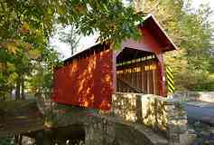
We head down Highway 240 and in no time we are Maryland…woot…cross another State off the “been there” list. The first town we come to is Thurmont, a tiny picturesque town, with of course farms surrounding it. It is nestled in the Catoctin Spur of the Blue Ridge Mountains and is very close to Camp David, the country retreat of the US President. We are driving through many covered bridges now, and I don’t know why, but to me, there is something magically romantic about them.
Once through Thurmont, we drive for a short while and are now in West Virginia. One of the places we end up driving through is Harpers Ferry. This is a really pretty place with a lot of hills (we are in the Appalachian Mountains after all)..hence we did not go for a walk around….yep…too lazy.
Harpers Ferry is is named after Robert Harper, who upon arriving in the area realized the potential of setting up a ferry there, since Harpers Ferry is situated between two rivers, the Shenandouh and the Potomac. The ferry came to be the only way to cross the rivers without travelling, at that time, for weeks, by land. The ferry operated until 1824, when covered bridges were then constructed to facilitate travel across the rivers. Harpers Ferry is also the site of the John Brown raid in 1859. John, along with several others, tried to take over the town and the munitions supplies from the factory that was located there. His idea was to arm slaves with weapons and to start a revolt against the slave owners. He failed in his attempt when the local folks forced John and his followers to hole up in a building. The Government sent in the militia, lead by General Robert E. Lee, who after a quick skirmish secured John and his group. John was tried for treason and was hanged in Charles Town shortly thereafter. Harpers Ferry is a well known rest spot for those hiking the Appalachian Trail, as the trail goes right through the middle of this town. It is a very picturesque spot, and well worth driving through if you are in that area.


On ward we go, driving through the gorgeous Appalachian Mountains…I thought the Blue Ridge Mountains were something, which they are, but the Appalchians have a real majesty all of their own.
Charles Town is our next drive through, and as I mentioned it does have some history relative to John Brown. The town was owned and named after George Washington’s youngest full brother, Charles. Many of the Washington brothers ended up making their home there over time. It is another really pretty town.
We are driving through the Shenandoah Valley…oh my, but it is gorgeous and lush. It is believed that the name came from the Native American Schin- han- dou, which means river through the spruces. There are numerous caves to explore here and due to the fertility of the soils, there is much agriculture and viticulture…aka…vineyards. I cannot say enough how blessed I felt and still feel that I was able to witness the beauty of nature and my words here will never be able to fully share it with you…get out and go see it for yourself…wherever you are.

The roads are curvy, smooth and the views just do not stop. I am not explaining all of the Civil War history that is associated with all of these towns, because that is not my intention. But if that is something that interests you, well, there is much to be read about these towns and the war. Harrisburg is one such place and what is interesting here is that the Rosetta Stone was created here…largely due to the fact that it is an ethnically diverse town and that the children in the public schools represent over 55 different languages.

We are driving highway 11 which runs perpendicular to the interstate. Its much more scenic on this route, however, there are not many towns to stop in or things to see…except the remarkable scenery…that was more than enough. I will share a couple of the towns with you.
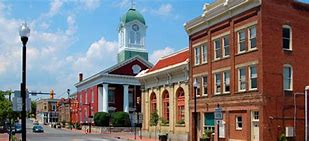
The first one is a lovely little city where we ate lunch was called Staunton. Because we are travelling off the interstate we drive right through the downtown of Staunton. We ate lunch at the Shenandoah Pizza and Tap House and it was delicious. Staunton is the birthplace of Woodrow Wilson, the 28th President of the USA, Staunton offers a great respite and many options to the tired and in my case, hungry, traveler. Staunton was known back in the day as a backwoods remote trading center. It became the area that coordinated the transportation of grains and tobacco from the local and surrounding area farmers in the backwoods to the major ports and other larger cities in the USA. In the early 19th century, there was an asylum built here…the Western State hospital. It offered it patients a very utopian atmosphere with terraced gardens and gorgeous mountain views. But, by the mid 19th century, the methods of treatment changed, due to overcrowding and the warehousing of patients. The treatments were less holistic and far more…shall we say…torturous. In the 1980’s the asylum moved and the building became a medium security prison for men. In 2003 the prison was closed, the land sold and the gorgeous “The Village” condominiums were built. It seems that there are many ghost stories associated with this property…I am not surprised…are you? Staunton is home to the Statler Brothers and they still reside here.

The next little town we drive through is a tiny town called Buchanan, with a population of only 1000. A cute little town, it is the birthplace of Hughie Thomasson of the band Lynard Skynard. Don’t blink or you will miss this little gem.
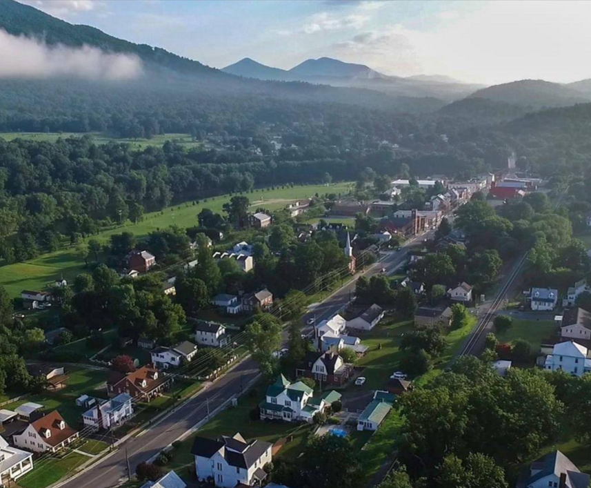
Roanoke is our next spot….most people have heard of this city. Roanoke was originally called “Big Lick”, named after a large outcrop of salt on the now Roanoke River. This salt lick attracted much wildlife, which made it a prime spot for hunting, therefore, a good spot for the settlers to plant some roots. The towns name was changed to Roanoke in a few years as a way to easily identify where it was situated (this makes perfect sense with it being on the Roanoke River and all). I am not certain of the year this occurred in, but at some point a Mr. Fred Kimball, a civil engineer and partner with the Clark Company that owned the Shenandoah Railroad, brought the railroad to Roanoke. Mr. Kimball, being a geology buff, went into the surrounding mountains looking for…well…geology finds. It was here that he discovered coal… and that led to the discovery of the Pocahontas Coalfields and the beginning of an industry that has long been a part of Virginia…coal mining. And as a real juxtaposition to this…Roanoke became known as a textile district. There were many mills in the area that manufactured cotton and other materials and fabrics for use in the USA and to be exported all over the world. And of great interest to many…this is the city where Las Vegas legend Wayne Newton was raised…danke shein my friends! (side note in case you are not aware of this Wayne Newton reference…it is the title of one of his famous songs…yep…I am that old…I mean knowledgeable).

Our final stop for the day is Christiansburg. It has been a long but beautiful day of driving and sightseeing and its now time for some dinner and to find a room. Christiansburg is named a after Colonel William Christian, who was one of the first justices of Virginia. Daniel Boone lived here and then he…um…”moved”. Apparently there is a document in a museum in Christiansburg, from 1774 that is a warrant for the arrest of Daniel Boone. It was issued for his non payment of a debt, and on the warrant it is written “not executed…gone to Kentucky”. Hence, Daniel Boone moved….with cause it seems…as a note…he later paid the debt in full… $8.00.
Another notable from Christiansburg is Davey Crocket. As a young man, Davey worked here as an apprentice for the newspaper printer.
William Clark of the famous Lewis and Clark expedition resided here at 109 East Main Street. The home is still in existence today…restored of course and it is now known as the Montague house, home to Civil War History of Virgin Tech.


Interesting to know…Christiansburg is the site of the first and last rifle duel in the Virginia. In May 1808, Thomas Lewis and John McHenry fought a duel with rifles. The end result…they both died. In January 1810, greatly influenced by this duel, a law was passed, outlawing any dueling in Virginia. An interesting way to settle disputes…however, not too effective in this case.

We end up getting a room at a Holiday Inn and look for a restaurant. I seem to recall that we had difficulty finding something open…not sure why. Eventually we find a Cracker Barrel restaurant that is open and in we go. We settle down and the waitress asks if we would like something to drink. I order a wine…and she stares at me with a very strange look. You see…Cracker Barrel restaurants do not serve alcohol. Why would I even consider having dinner here? Fail on my part. We order our meal and enjoy a lovely glass of…water to wash it down. Sigh.
Back to the hotel we go and plan the next days journey. This is exciting for me because tomorrow we will be in…The Smokey Mountains. You won’t believe the adventures we have tomorrow…but you can join me in my next blog and find out all about them.
Live Your Life….Jan

My gosh, everyone of your blogs have been so interesting and extremely captivating. It’s as though I’m on the back of the bike with ya’ll…My ‘To Do’ list of places to go keeps extending when reading these.
Soooooooooooooooo looking forward to the next adventure
Ronny
xo
LikeLiked by 1 person
Thanks Ronny. One day I will be writing about our adventures.
LikeLike